Have you ever wondered how services like Google Maps overlay traffic data and the location of the nearest coffee shop? Geographic Information System (GIS) software transforms raw geographic data into actionable insights, enabling organizations to analyze and understand spatial data. This practical application extends far beyond mapping, proving invaluable in asset management across various industries.
The GIS solutions market is experiencing substantial growth, projected to surge from $6.3 billion in 2020 to $25.5 billion by 2030. This surge reflects the increasing demand for precise location intelligence for targeted marketing campaigns and real-time decision-making.
Let’s explore how GIS empowers effective asset management.
The Power of Spatial Data in Asset Management
Strategic asset management relies on a clear understanding of complex geographic data. Challenges arise when this data originates from diverse sources in various formats. GIS software consolidates this data onto a single platform, enabling more accurate spatial data analysis and, consequently, improved strategic decision-making related to asset performance and lifecycle.
This article explores the practical application of geospatial software development in asset management and demonstrates how businesses can leverage geo-information. We’ll cover the key steps, tools, and technologies required to create GIS solutions for asset management and illustrate how specialized software development expertise can help create customized solutions.
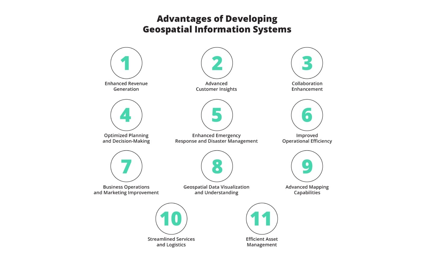
Benefits of GIS in Asset Management
A tailored GIS solution is more than just a map; it represents a comprehensive collection of processes designed to enhance the capabilities of any business. By enabling managers to make faster, data-driven decisions, handle operations efficiently, and identify new growth opportunities, GIS significantly improves asset management.
Here are key benefits of investing in custom GIS software for asset management:
1. Enhanced Asset Visibility: GIS provides a centralized platform for visualizing and tracking all assets, regardless of location. This includes real-time monitoring of asset condition, performance, and location, leading to proactive maintenance and reduced downtime.
2. Optimized Maintenance Scheduling: By analyzing spatial data related to asset performance and environmental factors, GIS enables predictive maintenance scheduling. This ensures that maintenance is performed only when needed, minimizing costs and maximizing asset lifespan.
3. Improved Risk Management: GIS helps identify potential risks associated with asset locations, such as flood zones, earthquake-prone areas, or proximity to hazardous materials. This enables proactive mitigation strategies to minimize potential damage and ensure business continuity.
4. Streamlined Operations: GIS automates many manual tasks related to asset management, such as data collection, reporting, and analysis. This frees up personnel to focus on more strategic initiatives, improving overall operational efficiency.
5. Better Resource Allocation: GIS helps optimize the allocation of resources, such as personnel, equipment, and materials, to ensure that they are deployed where they are needed most. This minimizes waste and maximizes the return on investment in asset management.
6. Compliance and Reporting: GIS facilitates compliance with regulatory requirements by providing accurate and auditable records of asset locations, conditions, and maintenance activities. This simplifies reporting and reduces the risk of penalties.
7. Data-Driven Decision Making: GIS empowers informed decision-making by providing a comprehensive view of asset-related data. This enables managers to make strategic decisions that improve asset performance, reduce costs, and maximize the value of their assets.
Understanding GIS Software Development for Asset Management
GIS software applications aid informed decisions by visualizing spatial data clearly. This clarity improves asset allocation, lifecycle planning, and risk management.
While open-source tools exist, they often lack the versatility and customization potential of solutions developed specifically for your business needs.
Customized GIS software improves productivity, reduces operational costs, and facilitates better decision-making. Furthermore, a licensed and trusted vendor ensures seamless integration with existing systems and processes, enhancing data management, increasing efficiency, and avoiding duplication of effort.
Key Components of GIS Software for Asset Management
GIS developers utilize a combination of standard software development techniques and tools specific to GIS applications. Your development team can help select the optimal mix of technologies and tools to meet your specific business needs in asset management.
Source: Matellio
GIS Software Libraries and Frameworks: These provide pre-built functions for common GIS tasks. Open-source options include GDAL/OGR, GeoTools, and OpenLayers. For greater flexibility, QGIS supports a wider range of functions and better control over software development.
Programming Languages: Depending on requirements, developers might use Python, Java, C++, or JavaScript.
Cloud Computing: Cloud platforms like Amazon Web Services (AWS) and Microsoft Azure enable GIS applications to leverage services without extensive infrastructure.
Spatial Databases: Managing spatial data with specialized databases is crucial. PostgreSQL/PostGIS and Oracle Spatial are two well-known options offering wide functionality and user-friendly features.
GIS Software Packages: Packages like ArcGIS, QGIS, and GRASS provide tools to capture, store, analyze, and display spatial data. They offer the development and functionality needed to maximize spatial data.
GIS software development involves a wide range of advanced tools and technologies adaptable to specific business needs.
Key Use Cases of GIS-Enabled Functionality in Asset Management
Organizations across various industries benefit from integrating GIS technology into asset management, improving network planning, maintenance, customer service, and overall operations.
Here are some notable GIS use cases in asset management:
1. Location Tracking and Monitoring: GIS allows real-time tracking of asset locations, providing insights into their movement and utilization. This is crucial for managing mobile assets, such as vehicles, equipment, and personnel.
2. Predictive Maintenance: By analyzing spatial data related to asset performance, environmental conditions, and maintenance history, GIS enables predictive maintenance scheduling. This ensures that maintenance is performed only when needed, minimizing downtime and reducing costs.
3. Risk Assessment and Mitigation: GIS helps identify potential risks associated with asset locations, such as flood zones, earthquake-prone areas, or proximity to hazardous materials. This enables proactive mitigation strategies to minimize potential damage and ensure business continuity.
4. Route Optimization: GIS optimizes routes for asset transportation and maintenance activities, minimizing travel time, fuel consumption, and wear and tear on assets. This improves efficiency and reduces costs.
5. Inventory Management: GIS provides a centralized platform for managing asset inventory, including location, condition, and maintenance history. This simplifies inventory tracking, reduces losses, and ensures that assets are readily available when needed.
6. Facility Management: GIS helps manage facilities by providing a comprehensive view of building layouts, equipment locations, and maintenance schedules. This improves facility efficiency, reduces energy consumption, and enhances safety.
Cost of Developing a GIS Software Application for Asset Management
When planning to build a GIS software application for asset management, several cost factors must be considered.
1. Features and Functionality: The complexity of your GIS software directly impacts the cost. Basic mapping and data layering will be more affordable than advanced features like 3D visualizations or real-time data analysis.
- Basic GIS application: $10,000 to $50,000
- Medium complexity: $50,000 to $150,000
- High-end: $150,000+
2. Development Team Expertise: An experienced team can cost more but delivers higher quality.
Freelancers: $20–$150/hr (varies by location and expertise)
Development agencies:
- US or Western Europe: $100–$250/hr
- Eastern Europe or South America: $40–$120/hr
- Asia: $20–$80/hr
3. Platform and Region: A web-based GIS app is typically more affordable than a mobile app, especially if developed for both iOS and Android.
-
Web application: Often more affordable due to the use of common tools and frameworks.
-
Mobile application: Costs can differ between iOS and Android and are higher if you want apps for both platforms.
4. Ongoing Maintenance and Updates: Regular maintenance, bug fixes, and updates are necessary.
- Maintenance and updates: Expect to spend around 10–20% of the initial cost per year.
5. Unforeseen Costs: Unexpected technical issues or changes in requirements can arise, so plan for the unexpected.
Factoring in these considerations provides a clearer picture of the GIS solution development cost.
Steps Involved in GIS Software Development for Asset Management
Developing a GIS application is a structured process requiring careful planning and collaboration.
Source: Matellio
1. Collecting Requirements: Define the application’s goals by identifying specific functionality, data sources, and integrations.
2. Design and Architecture: Define the system’s structure, select the right tools and technologies, and ensure scalability.
3. Development: Involves writing code, building features, and integrating databases, GIS libraries, and other tools.
4. Testing: Conduct manual and automated tests to identify and resolve bugs, performance issues, or compatibility problems.
5. Deployment: Move the software from development to production.
6. Maintenance: Continuous updates, bug fixes, and improvements ensure long-term reliability and performance.
Conclusion
GIS technology offers a practical and powerful solution for asset management across diverse industries. By leveraging spatial data, organizations can improve asset visibility, optimize maintenance scheduling, mitigate risks, streamline operations, and make data-driven decisions that enhance asset performance and maximize value. Investing in a custom GIS solution tailored to your specific needs can provide a significant competitive advantage and unlock the full potential of your assets.